
Anytime the year 2005 is used as a point of comparison, it’s bad news.
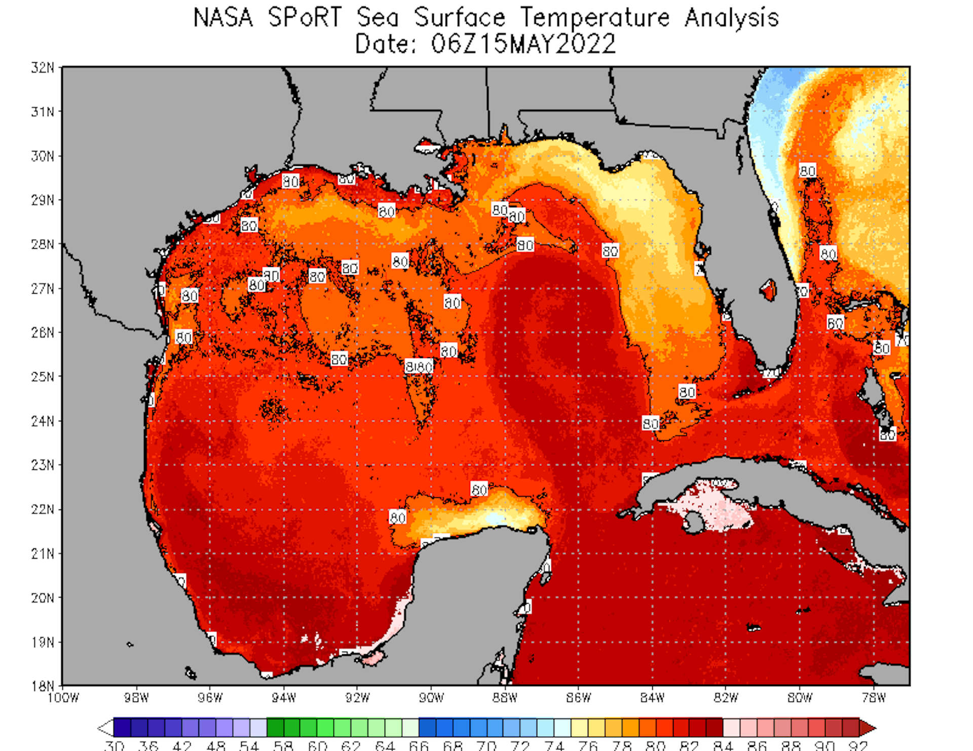
The Atlantic hurricane season starts on June 1, and the Gulf of Mexico is already warmer than average. Even more worrying is a current of warm tropical water that is looping unusually far into the Gulf for this time of year, with the power to turn tropical storms into monster hurricanes.
It’s called the Loop Current, and it’s the 800-pound gorilla of Gulf hurricane risks.
When the Loop Current reaches this far north this early in the hurricane season – especially during what’s forecast to be a busy season – it can spell disaster for folks along the Northern Gulf Coast, from Texas to Florida.
If you look at temperature maps of the Gulf of Mexico, you can easily spot the Loop Current. It curls up through the Yucatan Channel between Mexico and Cuba, into the Gulf of Mexico, and then swings back out through the Florida Strait south of Florida as the Florida Current, where it becomes the main contributor to the Gulf Stream.
When a tropical storm passes over the Loop Current or one of its giant eddies – large rotating pools of warm water that spin off from the current – the storm can explode in strength as it draws energy from the warm water.
This year, the Loop Current looks remarkably similar to the way it did in 2005, the year Hurricane Katrina crossed the Loop Current before devastating New Orleans. Of the 27 named storms that year, seven became major hurricanes. Wilma and Rita also crossed the Loop Current that year and became two of the most intense Atlantic hurricanes on record.
I have been monitoring ocean heat content for more than 30 years as a marine scientist. The conditions I’m seeing in the Gulf in May 2022 are cause for concern. One prominent forecast anticipates 19 tropical storms – 32% more than average – and nine hurricanes. The Loop Current has the potential to supercharge some of those storms.
It’s been a super warm month of May, so the conditions have not abated any. There’s only so much we can do about this right now except be prepared and hope for the best. At least now you know.
UPDATE: Just in time for more season predictions.
Hurricane season along the Atlantic Ocean is expected to be more active than usual this year, with a higher probability that major storms will make landfall in Texas and other areas along the eastern coast, the National Oceanic and Atmospheric Administration said Tuesday.
The Atlantic hurricane season officially starts June 1, and the national agency’s findings are consistent with other scientific organizations’ predictions. According to NOAA, there is a 65% chance the hurricane season will be more active than usual and only a 10% chance that this year will have below-average activity.
NOAA expects this season, which extends until Nov. 30, will have 14 to 21 named storms. Six to 10 could become hurricanes — including three to six major ones with winds of 111 mph or higher. The average season has 14 named storms.
If the prediction comes true, 2022 will be the seventh consecutive above-average season for Atlantic hurricanes in the U.S.
Factors like La Niña, warmer sea surface temperatures and an enhanced West African monsoon will all likely contribute to an above-average season this year, NOAA officials said. Climate change has contributed to make those phenomenons more intense, NOAA Administrator Rick Spinrad said Tuesday.
[…]
A Colorado State University study similarly found that probabilities for major hurricanes this season are higher than average, with a 71% chance of at least one major hurricane across the continental U.S. coastline, compared to an average 52% chance. The study also found that the Gulf Coast, from the Florida Panhandle to Brownsville, has a 46% chance of at least one major hurricane this season, which is 16% higher than last century’s average.
“Essentially everything is pointing toward an active Atlantic season,” said John Nielsen-Gammon, Texas state climatologist and director of the Texas Center for Climate Studies at Texas A&M University. “It doesn’t guarantee one but it makes it quite a bit more likely.”
Nielsen-Gammon said anywhere along the coast that’s less than 25 feet above sea level is potentially vulnerable to a storm surge, and that hurricane-force winds can be felt in Texas even hundreds of miles inland.
As I said before, maybe we need to redefine what an “average” season is now. In the meantime, get your supplies and have an evacuation plan in mind. And hope for the best.
Thanks. I bought a small camp stove for winter emergencies; it could come in handy this summer! Looking into a small battery-powered fan. The ice supply store nearby is still in operation; it had ice all through the Ike outage. 5 gallons of water in the closet; will increase that to 10. Gas up, folks before the last minute. Best of luck.
When Hurricane season starts, the gas tank gets topped off when it lowers to 3/4 full.