
A $200 million-plus plan to improve [Memorial Park] is aimed at making it a signature destination for all Houstonians. With that success, though, will come the same challenges anything popular in Houston faces: How will people get there, where will they park and what can be done to give them an option other than driving?
A variety of projects are planned or proposed to offer safer or additional options, including new bike paths, wider sidewalks, even a possible Metropolitan Transit Authority hub to rapid buses. All of the ideas, however, are years away and still face some public scrutiny that could alter the plans.
Efforts to create or expand trails follow what has been the largest park investment in a generation — a $70 million land bridge that creates a hillside through which Memorial Drive passes, connecting the park’s north and south sides.
[…]
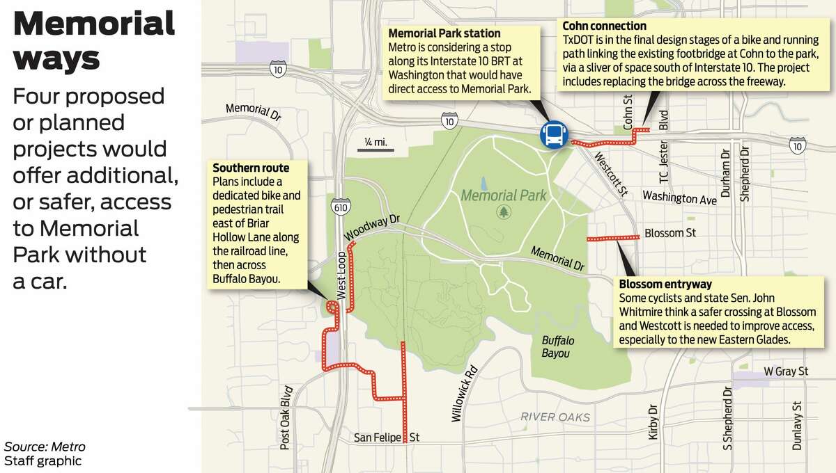
One of the biggest challenges to improving access to Memorial is the big roads that border it: Loop 610 and Interstate 10. Running along the west and north edges of the park, the freeways are a barrier where the freeway intersections with Washington Avenue to the northeast and Memorial and Woodway to the west can be chaotic for cyclists and pedestrians.
“What we want is a safe, easy, biking solution,” said Bob Ethington, director of research and economic development for the Uptown Houston District.
Ethington said along Loop 610, officials are considering how best to get runners and cyclists as far away from cars as practical. Those plans include a connection from the south, parallel to the Union Pacific Railroad tracks as far south as San Felipe.
The trail skirts a rail line south of the park, in the River Oaks area dotted with some of the most expensive homes within Loop 610. Other projects could follow, taking the trail as far as Brays Bayou and creating what could become a freeway of sorts for bicyclists between two popular bayou routes.
The key connection to the heart of Uptown, on the other side of Loop 610, is a planned trail running near the top of Uptown Park Boulevard, where it curves into the southbound frontage road, that will follow Buffalo Bayou beneath the clatter of 16 lanes of traffic above.
That connection, which could include a new bridge strictly for the trail across the bayou, would eliminate a stress-inducing street crossing for cyclists and runners at Woodway.
“The corner is terrible and the (Loop 610) underpass is not great,” said Randy Odinet, vice president of capital projects and facilities for the Memorial Park Conservancy.
The Uptown work, which follows Briar Hollow in the neighborhood south of Buffalo Bayou, recently received a boost, when $4 million of the $5.3 million price tag was included in the House version of a federal infrastructure bill at the request of Rep. Lizzie Fletcher, D-Houston, who represents the area.
For travelers headed to the park from the east, two planned projects could help. Construction is set to start in about 20 months on a new bike lane spliced through a narrow piece of public land on the south side of Interstate 10. The Texas Department of Transportation project would eliminate a broken link between the Heights and Shepherd corridors and Memorial Park, caused by I-10.
Now, cyclists can use the Heights Hike and Bike Trail and White Oak Trail to access the Cottage Grove neighborhood north of I-10, then a pedestrian bridge atop I-10 at Cohn. About a half-mile from the park at the end of the Cohn crossing, however, is where the easy access stops. The Union Pacific Railroad tracks and nearby streets force runners back to TC Jester, which many avoid because of the heavy traffic and truck volumes and high speeds.
Design of the TxDOT project is not finalized, but the work likely will include a trail along the south side of I-10 from Cohn to Washington, through a slice of state-owned right of way and beneath the UP tracks. At Washington, it is expected to cross at the intersection and into the park.
The project also will replace the Cohn bridge with a wider span and assorted street-level improvements north of I-10 along the frontage road.
Most Houston residents and travelers, however, cannot simply hop on a bike and get to the park. Current transit offerings are limited to three bus routes, two of which come every 30 minutes. The third, the Route 85 Antoine/Washington that skirts the eastern edge of the park, is the only frequent route, coming every 15 minutes. More than a dozen bus routes pull into the Northwest Transit Center less than 2,500 feet away from the park, but those 2,500 feet are impassable because of the I-10 interchange with Loop 610.
A planned bus rapid transit route along I-10, however, could radically improve access if Metro were to include a stop at the park. Metro officials, while not committing, said they are considering a possible stop at Washington on the park’s boundary.
The idea of a Memorial Park station has drawn interest from transit riders and officials. Often, transit is built and discussed in terms of moving people solely to jobs and schools, Metro board member Sanjay Ramabhadran said.
“It is also about getting us to recreation facilities, parks,” Ramabhadran said.
Plans for the BRT line include an elevated busway along I-10 so large buses can move in their own lanes from the Northwest Transit Center to downtown Houston. Transit officials plan various public meetings before any station decision is made.
“You cannot order a BRT corridor on Amazon and have it delivered next week,” Ramabhadran said.
It all sounds good to me, and you can see each of the planned items in the embedded image. Years ago, when it was still possible to dream about more light rail lines being built in Houston, I proposed a rail line that was a combination of Inner Katy/Washington Avenue and the current Uptown BRT line, which would have included a Memorial Drive segment. That was included for the purpose of making it easier for more people to get to one of Houston’s biggest parks and premier destinations. That idea will never happen, but seeing a proposal for a Memorial Park-accessible stop on the now-proposed Inner Katy BRT line makes me smile. It really is kind of crazy that the only way to get to Memorial Park for nearly everyone is to drive there, especially considering how impossible it used to be to park. There’s more parking now, but we could get a lot more people into Memorial Park if they didn’t have to drive to get there. I very much look forward to seeing these projects take shape.