
From Texas Redistricting:
Intentional Fragmentation
In the other parts of the map, redistricting plaintiffs contend that the Texas Legislature intentionally diluted African-American and Hispanic voting strength by fragmenting cohesive communities.
This fragmentation, they argue, is especially pronounced in the DFW Metroplex, where the court-drawn interim map (Plan H309) adopted the Texas Legislature’s map (Plan H283) without any changes.
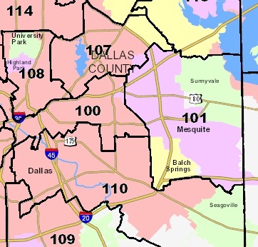
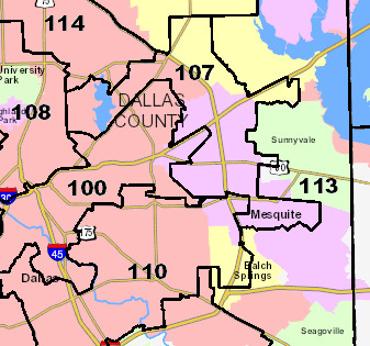
For example, prior to the 2011 round of redistricting, HD 101 was a compact district in eastern Dallas County, taking in all but small parts of Mesquite plus the adjacent town of Sunnyvale and heavily African-American and Hispanic Balch Springs.
However, under the plan adopted by the Legislature and incorporated by the court into its second interim map, the city of Mesquite was split into three districts, with part of the city’s non-Anglo population drawn into HD 107 and other parts drawn into HD 110 and HD 113. The city of Balch Springs, where non-Anglos now make up nearly 75% of the population, was similarly split.
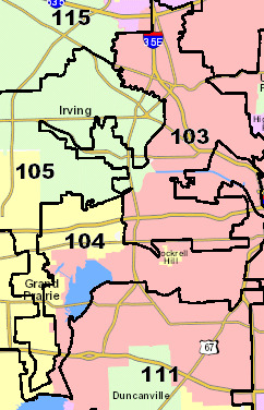
On the other side of Dallas County, the oddly shaped taproot in the redrawn HD 105 is another example cited by the plaintiffs of fragmentation.
The portions of the city of Grand Prairie to the west of the taproot include African-American neighborhoods separated out from African-American neighborhoods within the taproot.
The result is that HD 104, a Hispanic opportunity district represented by State Rep. Roberto Alonzo, becomes 19.2% African-American CVAP, while HD 105, a seat represented by an Anglo Republican Linda Harper-Brown, becomes several points less African-American than under the court’s initial interim map.
The plaintiffs’ pleadings point to other examples of fragmentation in Harris, Fort Bend, Bell, and McLennan counties.
The plaintiffs say this “purposeful fragmentation of minority voters … violated the equal protection principles laid down” by federal courts.
If the court agrees, it would have broad power to fix the fragmentation, much as it fixed similar fragmentation in the congressional map by creating CD-33 in the Metroplex.
This was part four of a series looking at the remaining disputes with the maps – see here, here, and here for the first three, here for Part Five, and click over for more on the legislative maps. The San Antonio court will hold a hearing today to begin to decide what to do with the legislative and Congressional maps, once they have direction from SCOTUS. The idea of making the interim maps the legislatively-passed maps is that it would strengthen the state’s hand in defending them, since these maps were drawn by the court in the first place. But the San Antonio court, which originally drew maps that were much friendlier to the Democrats, were constrained by a SCOTUS ruling that said they had to give deference to the original Lege-drawn maps. With the DC court’s ruling that there was intentional discrimination in these maps, I don’t think the hastily-drawn interim solutions will hold up. But I’m not a lawyer, so what do I know. Point is, we’re nowhere near the end of this fight.