
My wife came back from this month’s civic association meeting and handed me a flyer for this, along with more or less the exact words I’ve used in the title of this post.
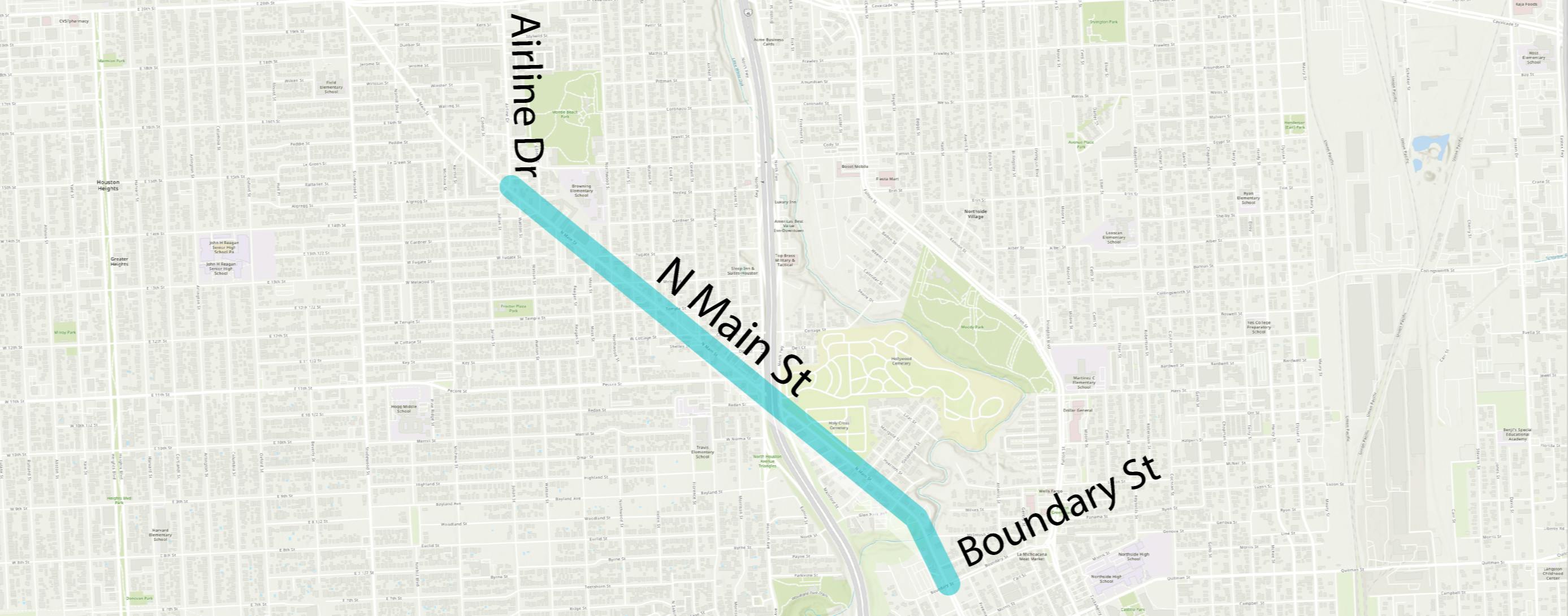
North Main Street runs north from I-10 bordering Downtown Houston to Crosstimbers St. in Independence Heights. It is a 5-mile stretch, including 1.2 miles with center-running light rail operated by METRO. North Main becomes a four-lane undivided street fronted by many local and small-scale businesses at Boundary Street, where the light rail deviates onto Fulton Street. The four-lane section between Boundary Street and Airline Drive is being improved for safety.
There are notable crash problems on North Main between Boundary St. and Airline Dr.
- More recently, between 2017-2021, there have been 224 total crashes, including eight crashes where someone was seriously injured.
- A half-mile segment between Holy Cross Cemetery and Melwood St is on the Vision Zero High Injury Network(External link) because there were two serious injury crashes and one fatal crash between 2014-2018. This segment includes the IH 45 intersection, which may be contributing to the higher number of severe crashes.
With substantial support from Council Member Cisneros, the City of Houston has been undergoing an analysis and redesign of North Main:
- As of March 2022, the project is at 95% design between Boundary Street and Cottage Street.
- At the same time, METRO has been redesigning one of their frequent bus routes, the 56, which runs along Airline Drive. In addition to improved bus service, the redesign includes high-comfort bike lanes from North Main St to W Cavalcade St. Airline Drive intersects with North Main.
- To connect the proposed bike lanes on Airline to the proposed bike lanes on North Main, the City is pursuing an extension of North Main to fill the 0.5-mile gap between Cottage St. and Airline Dr.
To get more information about existing conditions, please review the Overview document.
The Overview document and the presentation from a May 2021 meeting shows the work so far and the proposed solution, which if you’ve been following along you know will include a “lane diet”, better sidewalks with pedestrian refuge islands, and bike lanes. There’s a heat map of five years’ worth of car crashes along this stretch of road, and I am totally unsurprised that the left turn from North Main onto Pecore, which happens quickly after the I-45 intersection and right past the entrance to the McDonald’s on the corner, is the hottest spot on that map. I fully expect there will be whining about this, but as with the 11th Street project, this makes a lot of sense. I look forward to seeing future updates.
Much needed. I lived in Melwood for years and that whole stretch is a mess.
It sounds like a good idea. The police are not keeping us safe from the traffic. Vision Zero is not working out. Just before Easter, a guy and his dog out walking were killed on 25th street, by a truck, that admitted it was going about 40 mph down a residential side street. The police came and determined that the pedestrian was at fault: “failure to yield,” even though there is no sidewalk, and you got cars parked along the street, and it is not designed for speeds over 20. After the guy left the scene of the carnage, he crashed again, hit a parked Tesla, and this time, the cops claim that he was intoxicated. But the cops at the fatal accident didn’t notice.