
In Part One I described my weird idea to take a stroll into four Congressional districts, something I decided I could do after taking a close look at the new map in Houston. In Part 2, I took you on that walk with me. Now I’m going to show how this could be done elsewhere and with different types of districts.
We do redistricting every ten years, so you might wonder why I picked Congressional districts as the object of this little obsession. Congressional redistricting had national implications, of course. As this recent DMN story points out, Texas Republicans squeezed out four more districts than the overall electoral numbers suggest they were entitled to, giving them nearly all of the seats needed to achieve a majority in the House. I wasn’t thinking of that a year ago, of course, but I definitely spent more time thinking about the Congressional map than about the others. It was that new Congressional map that I had zoomed in on, to see what things looked like in my immediate area, that gave me the inspiration.
But what about those other maps? How about in the State House, where the districts are smaller and there are 24 of them in Harris County? (There ought to be 25, but that’s a whole ‘nother thing.) In the previous map, my neighborhood was sliced in half for no particular reason, which meant that I’d travel between HDs 145 and 148 every day walking my dog. Our neighborhood has been reunited under the new map, so I would need to travel a little farther to cross State House boundaries. That made me think, which State House districts did I pass through as I did Wednesday’s walk? Let’s take a look!

I started in HD145, entered HD147 when I turned south on Heights after walking along the boundary once I passed Studewood, and then reached the boundary with HD134 at Washington. I was fully in HD134 once I was west of Shepherd.
But look closer! With a slight modification, I could have started in HD142, on Jensen south of Lorraine, walked north to Quitman, then followed the same route to eventually get to HD134, with a terminus at the HEB just south of Washington. I didn’t fool around with Google Maps for this, but that looks like a roughly equivalent distance. I’m not surprised that this was doable in such close proximity, but I would not have guessed that these would be the four districts involved. This is why it’s fun to play with maps, kids.
That wasn’t where I had picked for what may be the shortest walk needed to be in four State House districts. Take a look at this:
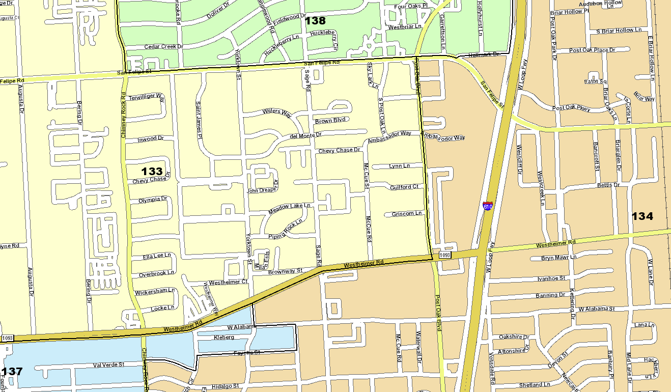
Just start on Yorktown and walk till you’re past Fayette. Google Maps shows this as 1.6 miles because it won’t let you cross San Felipe or Westheimer at Yorktown – it insists on making you hike all the way to Sage, then doubling back on Westheimer to return to Yorktown – so as the crow flies it’s probably not much more than a mile. Someone who knows that area better than I do will have to tell me why you can’t just walk all the way down Yorktown. Be that as it may, even with the detours, it’s a pretty short walk.
By the way, why is that tiny rectangle south of Westheimer and east of Chimney Rock in HD137 and not HD134? I have no idea. Either it’s a super-optimization of whatever evil redistricting software the Republicans used, or someone asked for that specific change for some reason. I’ll throw the question out to you if you think you know the answer.
There are a couple of other possibilities in Harris County. Zooming out a bit, south of I-10 and east of US59 you could get from HD142 to HD147 via HDs 142 and 145, and north of 610 you could get from HD141 to HD145 via HDs 140 and 142, though you’d have to cross US59 to do it, which might be dicey on foot.
Looking elsewhere in the state, I see possibilities in San Antonio, Austin, and Dallas, where I even see a possible five-district walk:
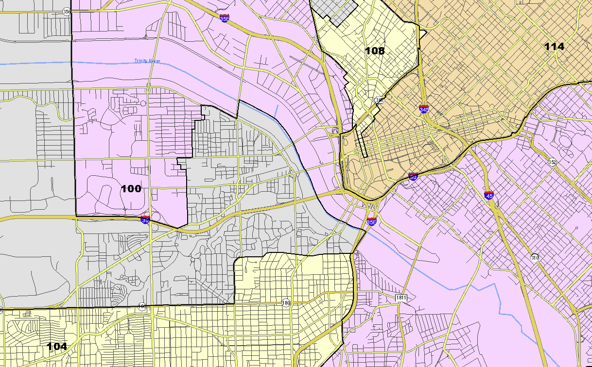
Start in that weird southern finger of HD108 and head south-ish to wind up in HD104, passing through HDs 114, 100, and 103 along the way. You have to cross the junction of I-30 and I-35, which sounds like a nightmare, but maybe it’s doable. Point is, these districts are all right up against each other.
You might think that State Senate districts would be too large for this, as there are eight fewer of them than there are Congressional districts. Challenge accepted:
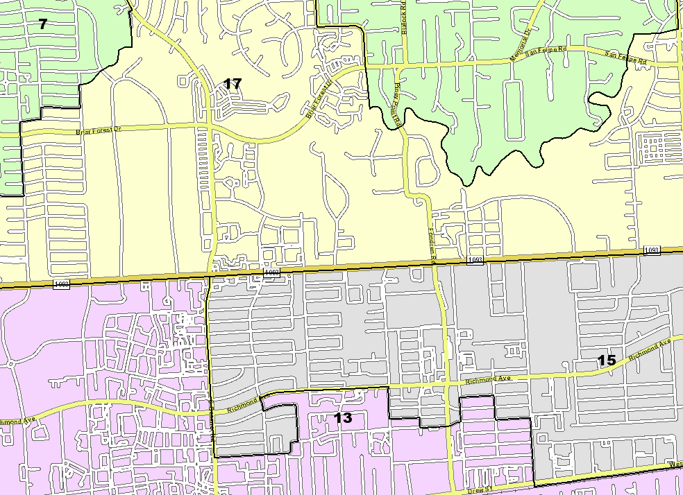
Start on Piney Point Road near San Felipe and head south as it becomes Fondren, and go a few blocks south of Richmond, to have visited SDs 07, 17, 15, and 13. There may be other possibilities elsewhere, but I was happy enough with that to quit looking.
Going back to Congress for a minute, I see opportunities again in San Antonio, Austin, and Dallas as before. That DMN story highlights a couple of places where the distance between one district and another, with a third in between, is ridiculously thin, like less than a quarter mile in the Dallas case. But just to finish this post, let me show you what my original walk route looked like under the old map:
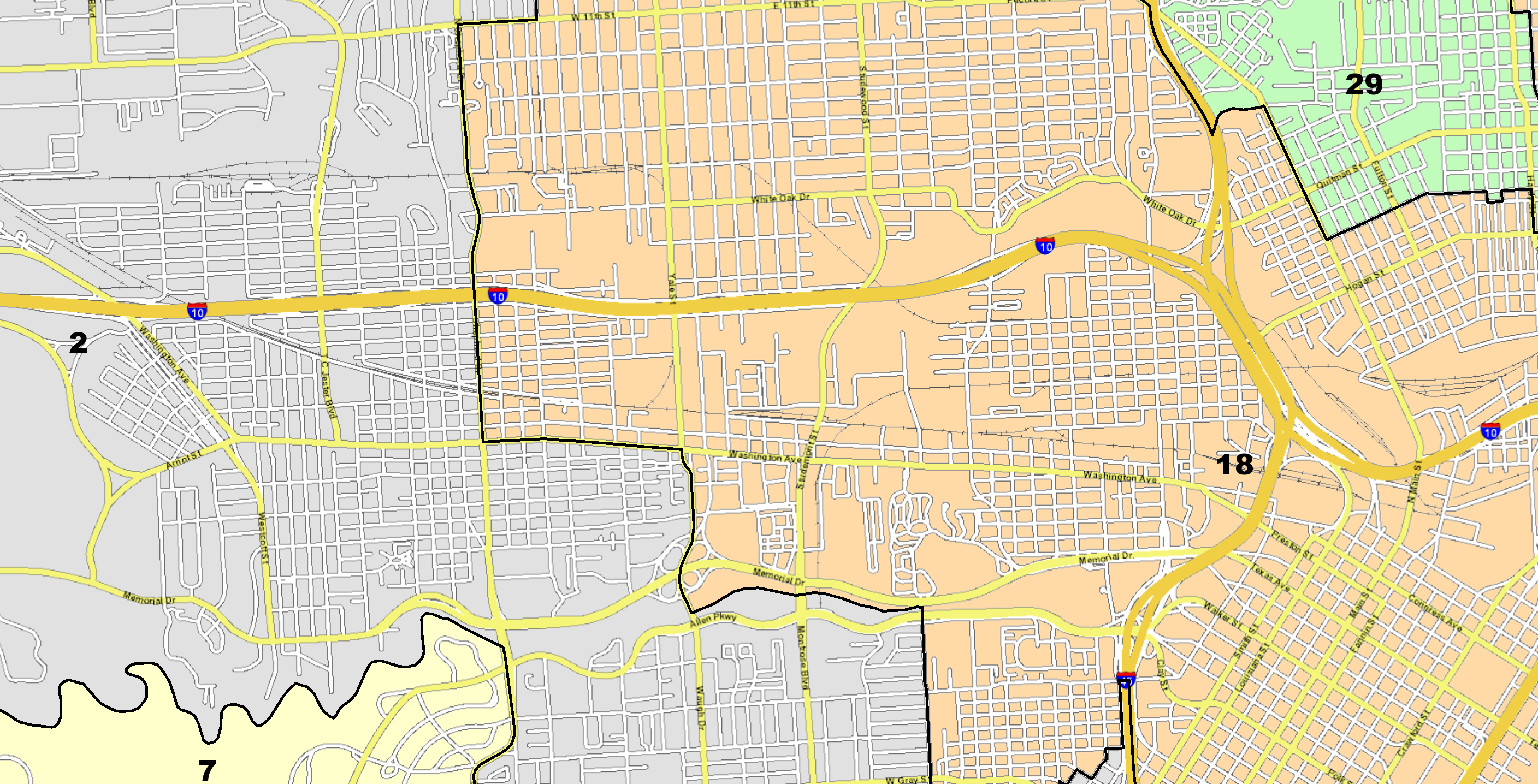
Starting a bit farther east on Quitman in CD29, I could have headed on Quitman to White Oak to either Studewood or Yale, then gone south to Allen Parkway and east to Shepherd to visit CDs 18, 02, and 07 along the way. That might even have been a slightly shorter walk. Just a reminder that this was a thing before I ever decided to try it out, and will likely continue to be a thing ten years from now when we do this all again. Now go play with those maps and plan your own walk.
PS: I should have noted sooner that John Nova Lomax did a great series of articles some years ago when he wrote for the Houston Press in which he walked the entire length of a well-known Houston thoroughfare – Richmond and Shepherd are the two I remember from the series – and wrote about the experience. Some of the walks he took were in excess of ten miles and took him all day; he had planned meal and bathroom stops along the way, out of necessity. I don’t have that on my itinerary any time soon, but I was thinking about it as I did this walk.
Charles:
I’ll point out another peculiarity for you. In the new redistricting, there is only one block in River Oaks that is in CD7. By coincidence, it happens to be the block where Lizzie Fletcher lives. All she has to do to walk to CD38 is to walk out of her house to the middle of the street. Which angel was watching over her during the redistricting?
“By the way, why is that tiny rectangle south of Westheimer and east of Chimney Rock in HD137 and not HD134? I have no idea. Either it’s a super-optimization of whatever evil redistricting software the Republicans used, or someone asked for that specific change for some reason. I’ll throw the question out to you if you think you know the answer.”
That shape could have been created during the redistricting following the 1990 census, and is probably one of numerous legacy lines that remain in Harris County from the 1991 re-districting. This particular shape may have been a district line continuously since 1991. You’d have to research the historical maps to determine its status over the years. 1991 was the year that the “Macy’s parking lot precinct” on the north side of The Galleria was created. It disappeared in a later re-districting.
I think John Nova Lomax also did Westheimer all the way to Hwy 6.
Charles, my memory retrieved another bit of info. The shape you commented on, and the other one just to the south at the NE corner of Chimney Rock and Richmond, were voting precincts carved out of Pct 0569 during a redistricting, most likely in 1991. I’m going by memory because I don’t know where to access maps from that time period.
If the sliver at Chimney Rock and Richmond was carved out in 1991 it was done by a Democrat legislature, probably for racial or ethnic reasons to maximize SD 15 or a state rep district for Hispanic population. Is there an apartment complex on the back side of those blocks which would have been largely Hispanic in 1990? That was the year we went in Harris County from about 400 to about 1300 precincts when the Democrats used census block data to carve apart the precincts in Montrose, Heights, Spring Branch and elsewhere surgically, and even 30 years later many of those precincts cannot be returned to their prior boundaries. Each government entity which redistricts uses these slivers to balance out population in their new districts in different ways, and since you cannot have multiple congressmen, state house, state senate within a single precinct, you cannot usually recombine precincts.
Voter Worker–I may have the 1991 maps in storage–will look.
Voter Worker–I found a poor map of 1980s precincts and Harris County congressional districts which clearly shows that all precincts in the Chimney Rock and Westheimer vicinity until 1990 were rectangles. The new 1992 CD 29 did not extend into that area, but the new CD 18, then held by Craig Washington, did, and the sliver was created in the 1990s redistricting by the Democrat-led legislature, when they sliced apart the old precincts. It appears that the sliver remained in CD7, which would have been Congressman Bill Archer, but a map of Hispanic and Black population by city block, from the Texas Legislative council, for the 1990 census shows all the rest of the original precinct had a high minority population, which is why it was assigned to CD18. It is possible that similar dynamics had already caused the area to be segregated apart during the drawing by the then-Democrat state senate of the new SD 15 which was intended to be a Hispanic opportunity district, and which I recall also extended into that area of town.
Mainstream, thanks for taking the trouble to find the map and then study it and bring the information here. There are still fragments of the 1992 plans’ impacts scattered across the county. The enormous sweep of that re-districting over the relatively simply-configured and long-lived voting precincts of Harris County was something to behold. Another new condition it brought was the appearance of numerous voting precincts with zero population, many of which have persisted until today.