
Yeah, it’s getting to be that time of year. From Space City Weather:
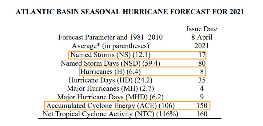
Good morning. The most reputable hurricane season forecasting service, led by Phil Klotzbach at Colorado State University, has released its first outlook for the 2021 Atlantic season. The forecast calls for above normal activity (see table below) with 17 named storms instead of the more typical 12; eight hurricanes instead of six; and about 50 percent total more activity, in terms of the duration and intensity of tropical systems, as measured by accumulated cyclone energy.
This outlook is consistent with other predictions, already released, in calling for a busier than normal season. What I like about Klotzbach’s forecast is that he’s very clear about his methodology—using a combination of statistical modeling, and historical correlations between Spring-time weather conditions and hurricane activity later in the year. Klotzbach also has a reasonable track record.
With that said, seasonal hurricane forecasts are far from perfect. I think, generally, we can expect a busier Atlantic season, but we’re almost certainly not going to see a brute of a year like 2020. Moreover, the chance of the Houston area being directly affected by serious tropical weather (in terms of floods, winds, or surge) is pretty low. Historically, the region only sees a significant storm about once a decade or so. Therefore, while it certainly is time to begin planning for the 2021 Atlantic season, I very much do not want you to start worrying or obsessing about it. Matt and I will, of course, be here every step of the way, and we’ll be releasing a new app before the June 1 beginning of the season to keep you informed.
“Not as bad as 2020” is a low bar to clear, but we have to start somewhere. There will be other forecasts, and that will give us a fuller picture of what is expected. Also of importance is predicting the development and path and severity of hurricanes and big rainstorms, and towards that end the NOAA rolled out a new model last month.
“You just get a better forecast,” said Lance Wood, a meteorologist with the National Weather Service’s Houston/Galveston office. “The day-to-day reliability of the model forecasting would be better, though it would probably be more noticeable in something like an extreme rainfall threat.”
The upgrades include a variety of changes. For one, the Global Forecast System (an atmospheric model) can now interact with a global wave model. Running these models together will extend wave forecasts to 16 days, up from the current 10-day forecasts. This is particularly helpful to mariners planning long-distance voyages, Wood said.
The upgrades also provide a more detailed look at the atmosphere at various vertical levels. Previously, the model showed data at 64 different levels in the atmosphere. Now, it will show 127 different levels. This type of information can help provide more accurate cloud coverage forecasts — a weather outlook that’s often requested by general aviation pilots who want to know how thick the clouds will be.
And finally, the new-and-improved Global Forecast System will be able to pull more data from satellites that provide weather observations and planes that measure wind, temperature and moisture, Wood said.
In other words, we’ll have more time in advance of a hurricane to know that it’s coming and to prep for it. We need all the help we can get with that. Stay alert, be prepared, don’t panic, and we’ll get through this.