
After I wrote about the effort to get two new bike and pedestrian bridges built in the Heights area, with the intent of making some new connections across the White Oak Bayou and to the existing White Oak Bayou Trail, I realized that I didn’t have a good image in my head of where these proposed sites would be. The map on the A Tale Of Two Bridges page helps, but the conceptual pictures they have on the home page didn’t really put in context for me. (*) So I decided to head out on my own over a recent weekend, on my bike of course, to find the future landing spots and take some pictures.
(Note: you might also find it useful to bring up a Google map of the general area – here’s one centered on the Heights Bird Sanctuary, mentioned below. Later in the post I talk about points of interest farther south, and I found it helpful to see where I was on this map as well.)
The first place I visited was the junction of Allston and 5th streets – you should probably refer to that map as I go along. Basically, 5th street runs for one block west of Yale, then ends at Allston, which also ends there. At this little two-street cul-de-sac, there’s a mini-dog park on 5th and the Assembly at Historic Heights apartments on one side of Allston and more apartments on the other. There’s also a small grassy field that overlooks the bayou, with some people-made walking trails that take you into the nearby Houston Heights Bird Sanctuary. This is what you see from the cul-de-sac:

I walked from there to the steep (and on a wet day, slippery and treacherous) dropoff to the bayou. It was far enough down that I couldn’t really see it, and with the ground as slick as it was I wasn’t going to chance getting any closer. But you could easily see the bike trail from there:

You can see a bicyclist and a runner catching a breather if you zoom in. A bit to the east is an entrance to the trail from Bonner Street, but unless you live there or continue on to the I-10 service road, you can’t really get anywhere else from there. But you can easily get to the Yale and Heights Blvd ramps from the trail. Or you could continue west towards Patterson. The current alternative to get there is to go back to the Heights Bike Trail, two blocks north on Allston, then take it all the way to Bayou Greenways Park, just over the MKT Bridge by Studewood, and pick up the White Oak trail from there. It’s a long damn way that way.
Speaking of Patterson, here’s the view of about where a Patterson bridge would connect on the north side. There’s no specific feature here, just a stretch of 6th Street between Waverly and North Shepherd. It had started to rain by the time I got here, and I took temporary refuge under a stairway at The Standard apartments. Not the view I would have preferred to show, but you can at least see the new Patterson Park bar from here:
As I said, the landing point is this stretch of 6th Street, which now features MKT Heights as a destination. From Waverly you can get back to the Heights trail, which will connect back to the White Oak trail west of Durham; you can also get to the northern spur of the Heights trail on Nicholson.
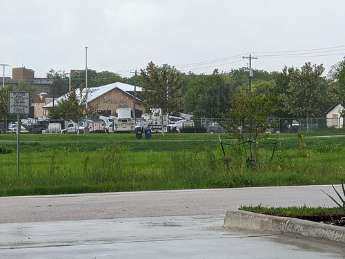
That was the end of that day’s journey – I still had a rain-soaked ride home. By Sunday it was clear enough again, so I headed to the White Oak trail to see the perspective from the other side. I can’t say exactly where on the trail the bridge to 5th and Allston would be, but it’s in this vicinity, where you can see the Assembly apartments:

Part of that clearing I mentioned is where that utility pole is just left of the photo’s center. I was to the right from there, peeking out from the smaller trees, when I took the first picture.
The dead end of Patterson Street at the trail is a lot more obvious, and that’s where I took these last two pictures, one facing slightly east towards The Standard, and the other facing slightly west, in the general direction of MKT Heights.
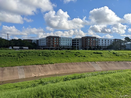
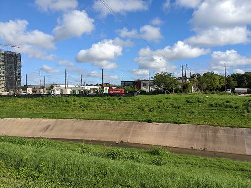
I think the construction you can see in the west-facing picture on the bottom may be the back end of the East Bend apartments, which front onto North Shepherd. Patterson, on the side where I was, will have an on-street bike trail built soon per that Chron story. It will take you over I-10 to Washington Avenue. From there, you can eventually get to the Buffalo Bayou bike trails between Memorial and Allen Parkway either via Jackson Hill Street a couple of blocks east, or via Feagen to Spotts Park. You do have to cross Waugh to get there, which is dicey, but perhaps that will be addressed at some point as well. It’s still an amazing extension of the existing bike trail network, all thanks to two bridges and a new street trail. I don’t know about you, but I’m excited to see it all happen. Hope you enjoyed my little photo tour of what is to come.
(*) I did come across a better picture in this Axios Houston story as I started writing this post, but by then I’d already taken my own pics, and this one still wouldn’t have made sense to me without my own visit to the locations.